Background
I remind you of what I believe to be an essential background context to all the walks: Leaside as a designed cultural heritage landscape – features that make Leaside Leaside – the Todd town plan (streets layout), the tract development of the 1930s through to 1953, and the few “stranded” settler homes, all of which are set over the earlier Colonial grid.
1. Leaside is believed to be the first new town in Ontario based on Garden City principles, designed as a complete community with residential (west) and industrial (east) uses in 1912 by American-born Frederick Gage Todd, the Montreal landscape architect and one of the founders of the Canadian Society of Landscape Architects. He apprenticed at Olmsted, Olmsted and Eliot in Brookline, Ma. and was responsible for other model towns in Canada: Mount Royal (Montreal), Shaughnessy Heights and Port Mann (Vancouver), Bowling Green (Port Claire, PQ) and Point Grey, BC. Todd’s street layout sits within the meta grid of Bayview and Eglinton, the railway lines to the southeast, and the Don River.
2. Leaside presents gently curving and diagonal streets with a rhythmic consistency of uniform setbacks and Modern Classicism style architecture including Tudor and Georgian Revival, and Art Moderne and Beaux Arts (former Bayview Playhouse and Agnes Macphail House). The planned diversity of housing types includes single, semi, multi-family and bungalow house forms, and one/two/three storey heights.
Unique (for Canada) is a concentration of “garden apartment” style multi-family walkup apartment buildings, i.e. Garden Court Apartments (1477 Bayview Avenue); the Talbot Apartments (three blocks – Kelvin Grove, Strathavon, and Glen-Leven – Bayview) and Crestview Apartments (Leacrest/Mallory).
3. Several “stranded” houses of early settlers (John Lea Jr., James Lea, Thomas Elgie) are placed in relation to their farms, and the lanes by which they were connected to Bayview and ultimately to Yonge Street, but misplaced in relation to the current street pattern.
4. And finally, Leaside was an independent municipality from 1913 until 1967, when it amalgamated with the Township of East York, and in 1998 it was amalgamated with the other five municipalities to become part of the City of Toronto.
Walking Tour of West Central Leaside
Acknowledgements:
The Walking Tour is based on an earlier walking tour on May 24, 2015 which was led by Connor Turnbull of Leaside Matters and Geoff Kettel of Leaside Property Owners Association based on research by Paul Dilse, Heritage Planner, in conjunction with The Cultural Landscape Foundation conference held in Toronto at that time.
Note: A useful accompaniment to this Walking Tour is the Cultural Heritage Landscapes of Leaside booklet (2015) produced by Leaside Matters under the leadership of Connor Turnbull and Kim Auchinachie. This can be found on-line at:
https://leasidematters.ca/wp-content/uploads/2015/09/1072-Leaside-Cultural-Heritage-book-V6-20150519_1200_SM.pdf
Introduction
Leaside is a designed cultural heritage landscape – it features the Todd town plan (streets layout), the tract development of the 1930’s through to 1953, and a few stranded settler homes, set over the earlier Colonial grid.
1. Leaside is believed to be (and likely is) the first new town in Ontario based on Garden City principles. Designed as a complete community with residential (west) and industrial (east) uses in 1912 by American born Frederick Gage Todd, the Montreal landscape architect, one of the founders of the Canadian Society of Landscape Architects. He apprenticed at Olmsted, Olmsted and Eliot in Brookline, Massachusetts and was responsible for other model towns in Canada: Mount Royal (Montreal, PQ), Shaughnessy Heights and Port Mann (Vancouver, BC), and Bowling Green (Port Claire, PQ) and Point Grey, BC. Todd’s street layout sits within the meta grid of Bayview, and Eglinton, the railway lines to the south east, and the Don River.
2. Leaside presents gently curving and diagonal streets with a rhythmic consistency of uniform setbacks and Modern Classicism style architecture including Tudor and Georgian Revival, Art Moderne and Beaux Arts (former Bayview Playhouse and Agnes Macphail House). The planned diversity of housing types includes single, semi, multi-family and bungalow house forms, and one/two/three storey heights.
Unique (for Canada) is a concentration of “garden apartment” style multi-family walk-up apartment buildings, i.e. Garden Court Apartments (1477 Bayview Avenue); the Talbot Apartments (3 blocks – Kelvin Grove, Strathavon, and Glen-Leven) (Bayview) and Crestview Apartments (Leacrest/Mallory)
3. Several “stranded” houses of early settlers (John Lea Jr., James Lea, Thomas Elgie) are placed in relation to their farms, and the lanes by which they were connected to Bayview and ultimately to Yonge Street, but mis-placed in relation to the current street pattern based on Todd’s plan.
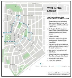
Start (and end) point: Bayview Avenue at Millwood Road
1. Single-detached houses on Millwood Road, between Bayview Avenue and Donegall Drive, and St. Anselm Roman Catholic Church
2. MacNaughton Road streetscapes, Father Caulfield Park at the intersection of MacNaughton Road and Cameron Crescent
3. Parkhurst Boulevard
4. Sharron Drive and Bessborough Drive,Bessborough Public School
5. Junction of McRae Drive, Sharron Drive and Rumsey Road, Leaside Branch of the Toronto Public Library
6. Semi-detached houses at Heath and Airdrie Roads
7. Millwood Road at Rumsey Road, Trace Manes Park and Leaside United Church
8. Bessborough Drive at Rumsey Road
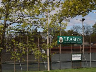
9. Garden Court Apartments
Introductory Remarks
Our tour of a small part of the Leaside neighbourhood serves as an introduction to a few of the features that characterize the Leaside cultural heritage landscape. To begin our walk, let’s first refresh our historical knowledge about the garden city movement. In 1898, Ebenezer Howard’s synthesis of nineteenth-century ideas about planning whole new towns in the countryside was formulated in his highly influential book, To-morrow: A Peaceful Path to Real Reform. The Letchworth lands, 35 miles from London, were assembled in 1903; and in 1904, architects Raymond Unwin and Barry Parker turned Howard’s garden city diagrammatic concept into Letchworth Garden City, the first new town designed on garden city principles in the world.
In 1912, only eight years after the launch of the world’s first garden city at Letchworth, the Montreal landscape architect Frederick Gage Todd laid out the Town of Leaside.
Stop 1. Millwood Road, between Bayview Avenue and Donegall Drive, and St. Anselm Roman Catholic Church
Although architectural control was stringent in the new town’s formative years, a variety of housing types and styles resulted, and made for the town’s harmonious streetscapes. Look at four different single-detached houses in the Millwood Road block between Bayview Avenue and Donegall Drive. The house at 711 Millwood Road is an example of Modern Classicism (note the two entrances – one private and the other for patients entering the doctor’s office). The house at No. 719 has Arts and Crafts influence. Note the small garage at the back of the house. The house at No. 721 is a Tudor Revival bungalow. Then across the road, the house at No. 720, which is a duplex in Art Moderne style, and was the home of Agnes Macphail, the first woman elected to the Canadian Parliament.
None of the town’s churches were erected to be grand landmarks; and the most imposing church, St. Anselm’s Roman Catholic Church, is still understated. Architect Arthur Taylor’s design, radically different from the earlier church on the site, anticipated liturgical reforms expected to come out of the Second Vatican Council of 1962-65. The huge window facing Millwood Road focuses on ecumenism, portraying symbols from Islam, Buddhism, Judaism, Hinduism, and Christianity.
We’ll turn onto MacNaughton Road, one of the many Leaside streets that retain their harmony of height, scale and material.
Stop 2. MacNaughton Road streetscapes, Father Caulfield Park at the intersection of MacNaughton Road and Cameron Crescent
Todd’s 1912 plan for Leaside offered a street hierarchy. Most residential streets were 66 feet wide, intended for local traffic. Four thoroughfares – one as wide as 110 feet – collected and moved through traffic. Many of the streets curve in contrast to the pre-existing grid of York Township roads surveyed between 1791 and 1798. The streets’ curvature creates interesting and surprising views where streets intersect, and a range of house lot configurations. Father Caulfield Park, is a “pocket park” a well used public space in what would have been an “awkward” house lot configuration.
Stop 3. Parkhurst Boulevard
Parkhurst Boulevard is one of the few streets that pass through from North Toronto to Leaside and coming into Leaside from the west, Parkhurst exemplifies the essence of Leaside architectural character as described by Stephen Otto in his book “East/West: A Guide to Where People Live in Downtown Toronto” (2000).
“….Street after street is flanked by handsome boulevard trees and tidy single family homes in stripped down Georgian or Tudorbethan style, each set back from the road an identical distance, on a comfortable lot with a private driveway…. The area remains a desirable neighbourhood to live in.”
One of the builders responsible for the “Tudorbethan” style in Leaside Is Henry Howard Talbot, builder, and later, Mayor of Leaside. Talbot built houses on Parkhurst Boulevard (and others on Donegall Drive, Cameron Crescent and Bessborough Drive). including 62 Parkhurst which he built and lived in. Talbot is notable for a range of fine projects including the quadraplexes (double duplexes) on Bayview north of Parkhurst, and his largest project, the low rise garden apartments south of McRae. He was also, as Mayor, the champion for building the Town Hall at McRae Drive and Sutherland Drive.
Stop 4. Sharron Drive and Bessborough Public School
Again, at this corner, we see how architectural regulation exercised by the York Land Company permitted some variety in single-detached house types. The Tudor Revival bungalow at 222 Sharon Drive is across the street from the two-storey Arts and Crafts house at 224 Bessborough Drive. Note the compatible addition on the Arts and Crafts house and the ash tree in its front yard.
Todd’s plan did not assign school grounds. The town selected a 3 1/4-acre block, intended for house lots in Todd’s plan, for the first elementary school – Leaside Public School, now called Bessborough Public School. In 1923, four classrooms and an auditorium were built to plans by S.B. Coon & Son, architects who specialized in school design. The school’s basement accommodated a small municipal office and the police department. In the next decade, the school grew in a series of additions.
Walking on Sharron Drive eastward from Bessborough Drive to Hanna Road note the remarkable architectural consistency – yet each house is individually different; continue east from Hanna Road to Rumsey Road. How do you account for the differences between the two blocks?
Stop 5. Junction of McRae Drive, Sharron Drive and Rumsey Road
Here at the junction of McRae Drive, and Sharron Drive (formerly Clowes) lies 45 Sharron Drive (formerly 1 Clowes), a property that has significant heritage interest based on period, architectural design, and association with Leaside civic leadership. The property is a prime landmark location on a direct sight line view to Laird and McRae.
It is representative of the first phase of house building in Leaside, around 1920, the first home built in the McRae/Clowes area. We know this because the November 11, 1919 minutes of town council record that “Mr. Wilkinson will be allowed the sum of $75 towards the expense of diverting electric light wires and poles to his house (1 Clowes). George Wilkinson, the owner was station agent for the Parkdale station of the Canadian Pacific Railway, and his wife was the postmistress and worked at the first post office at Perrem and Knight’s general store on the corner at McRae Drive and Sutherland Drive. They raised three children and lived there till about 1950. George Wilkinson was elected to the Town of Leaside in 1917 and continued to 1930 (except 1921) and was elected Mayor of Town of Leaside from 1931 to 1935, a total of 22 years of service to Leaside.
In addition, the house’s style (elements of Colonial Revival style, with aspects of Dutch Colonial Revival (gambrel roof) and Georgian Revival (sash windows, louvred shutters) is distinctive and unusual in the context of the prevailing Georgian and Tudor Revival style of Leaside. Not really surprising – while 1 Clowes was built on the Town of Leaside lot (and road) plan it would be up to 20 years before other lots in the area would be built on.
And look south west to the Leaside Branch of the Toronto Public Library. The library is a replacement in 2002 of the Leaside Public Library built in 1949. It has a Prairie school architecture in the Frank Lloyd Wright tradition feel to it,
Stop 6. Semi-detached houses at Heath and Airdrie Roads
In addition to one-storey bungalows and two-storey houses, two-storey semi-detached houses were offered by builders during the Leaside housing boom, which lasted from 1928 to 1953. Brick construction, hip roofs and Classical details on the semis reflected the same architectural characteristics as on the single-detached houses. On some Leaside streets, there are long, sweeping rows of semis uniformly set back from the curving streets while there are short clusters of semis elsewhere. So far, semis have been spared from redevelopment unlike the single-detached houses. Upper-floor additions began appearing on one-storey bungalows by the late 1970s, but purchasers of Leaside properties are increasingly acquiring both brick bungalows and brick two-storey houses to demolish them and build frame replacement houses that are too tall, of different profile, and faced with an assortment of unusual veneers.
Stop 7. Millwood Road, Trace Manes Park and Leaside United Church
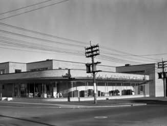
Anticipating development, property owners along Millwood Road in 1927 petitioned Leaside Town Council to make it a business street. The result on the stretch of Millwood Road from Airdrie Road to Rumsey Road was commercial rows like those on Bayview Avenue and small-scale apartment houses.
In 1931, the Town acquired lots in the 3.83-acre triangular block enclosed by Millwood Road, McRae Drive and Rumsey Road for the town’s first public park. Originally called Millwood Road Park, it was renamed Trace Manes Park to honour the town’s mayor of that name from 1948-50.
Leaside United Church, “at the heart of Leaside” with the choicest location in town, overlooking Trace Manes Park, is domestic in scale, walls of Credit Valley sandstone rising modestly in its naturalistic setting. The Church was designed in a cruciform plan by architects J. Francis Brown & Son. The sanctuary opened in 1941, to which a north wing was added in 1951 and a south wing in 1968.
Stop 8. Rumsey Road and Bessborough Drive
We’ll turn onto Rumsey Road, another Leaside street that retains its harmony of height, scale and material.
Bessborough Drive, formerly called Edith Avenue, has the widest right-of-way in Leaside. Todd wanted the street to parallel Bayview Avenue, but on a winding course from the town’s south limits to the north limits. Parts of Todd’s vision for Edith Avenue were later modified with reduction in width, straightening or interruption, but here the street’s original design supports impressive treed boulevards.
Stop 9. Garden Court Apartments
On the large Bayview Avenue block Todd had left open in his 1912 plan, the Berney Realty Corporation Limited and the Jackson-Lewis Company Limited built the Garden Court Apartments, in 1939-1942. Architects Forsey Page & Steele designed the garden apartments in Art Moderne style, each apartment extending from one side of the building to the other and with entrances and stairways serving four to six apartments. Garden Court is the second complex of garden apartments in Leaside – the other is the Talbot Apartments south of McRae in 1939 to 1942. The landscape architect H.B. Dunnington-Grubb designed the project’s central courtyard, over an acre and a half in size, laid out axially.
Concluding Remarks
Leaside is changing. Mixed use land use designations target intensification around the edges of the neighbourhood. Tear-downs and infill developments are permitted where the historic housing is located. Once at the forefront of town planning in Canada, Leaside is poorly served by the existing planning regime. Ironically, the Leaside community where planning control was stringent in its formative years lacks effective planning regulation now.