
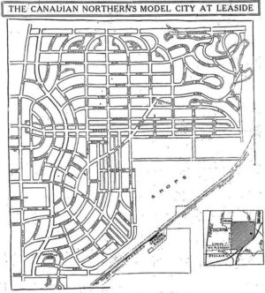
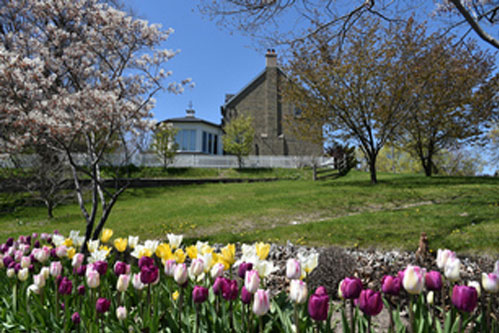
The second self-guided walking tour of Leaside takes us to North Leaside. Where does North Leaside in fact start? Typically, we think of North Leaside as that part north of Eglinton. If you look at the map showing the walk route, you might be surprised to find that the first stop is south of Eglinton. We did that for a couple of reasons. First, going back to Leaside’s origins, Eglinton was not even considered, and Soudan, as it was then called (later renamed Parkhurst), was planned as the main east-west route in the north of Leaside (see the historic map, right). Second, the West Central Leaside walk went as far north as Parkhurst, not to Eglinton, and we really wanted to include the Elgie estate! The walk is broken into nine points to stand and read, watch and maybe listen!

Note: The below walking map shows two ways of reaching Stop 2 – the Elgie House at 262 Bessborough Drive and Stop 3 at Eglinton and Donlea/Bessborough. One involves significant elevation changes – goes around the edge of the Leaside High School playing field and involves navigating trails on hills, with and without stairs. The other avoids significant elevation changes by taking Fleming Crescent and Parkhurst Boulevard to the Elgie House stop (262 Bessborough Drive) and then to Hanna Road and Eglinton.
Jane’s Walks Leaside
North Leaside
Preamble
The Jane’s Walks Leaside focus on the architectural and landscape features that make Leaside a great place to live, work, and visit. For illustrations and definitions of Leaside architectural styles go to Leaside Life, April, May and December 2018 editions (web link below).
https://leasidelife.com/an-architectural-guide-to-leaside-house-styles-part-i/
https://leasidelife.com/an-architectural-guide-to-leaside-house-styles-part-ii/
https://leasidelife.com/an-architectural-guide-to-leaside-house-styles-part-iii/
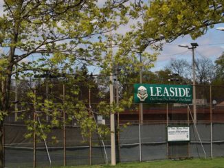
Stop 1: Bayview and Eglinton
Perhaps you came out of the Leaside station on the Crosstown LRT? (Oh – maybe not yet – at least for a year or so?). Anyway, this intersection is set for major change over the next few years. Sunnybrook Plaza on the north east corner will be replaced by a mixed use development having 12 and 16 storey towers, and something similar is expected on the south-east corner as well.
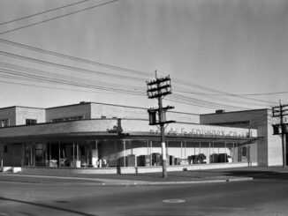
Sunnybrook Plaza (NE corner)
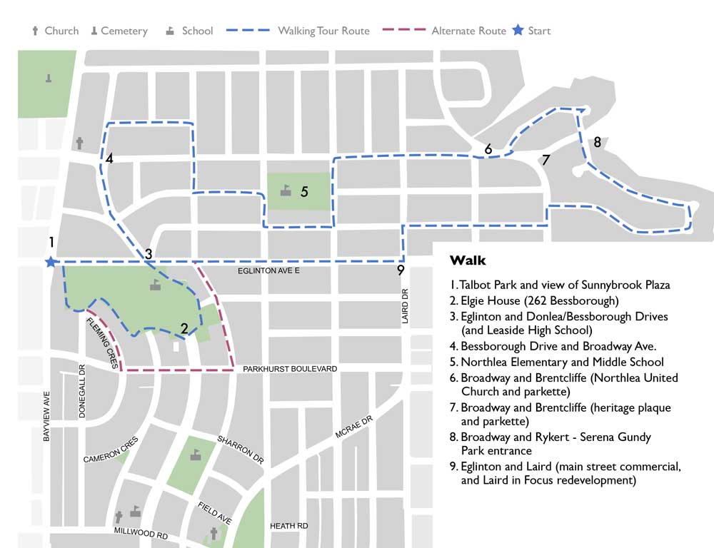
Sunnybrook Plaza was the first “suburban” shopping plaza built in Ontario and possibly Canada (see archival photo). Here’s a quote that captures its significance:
“In 1952 the same year that saw the launching of Don Mills saw the opening of Sunnybrook, Ontario’s first planned shopping centre at the corner of Eglinton and Bayview, strategically located to benefit from the growth of the adjacent suburb of Leaside.
The idea was revolutionary; you parked your car in a safe, paved and well-lit lot and then went about all your shopping needs in timely convenient fashion. A year later the same firm that put up Sunnybrook created the Lawrence Plaza at Lawrence and Bathurst, and a year after that the Golden Mile at Eglinton and Victoria Park in what was then the Township of Scarborough. These beachheads were the forerunners of the hundreds of malls, from the humble roadside strips to the megasize monsters like Yorkdale that characterize suburban Toronto today.”
Source: Toronto: A short illustrated history of its first 12,000 years, page 106
Ed. Ronald F. Williamson, James Lorimer Publishers, Toronto, 2008
Talbot Park (SE corner)
Named for Howard Talbot, a former Mayor of Leaside, the Park was completed in 1944.
The property consisted of swampy lowlands bounded by high banks on the south, with a small creek, Walmsley Brook, a tributary stream of the West Don, flowing through from west to east. Eventually; the water from the creek collected in the town sewers at Hanna Road. Grading of the park was started in 1948. The ball field was built in 1950 and the bowling green commenced in 1951.
Your walk from Bayview and Eglinton to 262 Bessborough will take you to the meeting point of Donegall Drive and Fleming Crescent above Talbot Park. From there you can either take the steps down and the trail at the foot of the slope, or to follow Fleming Crescent and Parkhurst Boulevard and Bessborough Drive.
73 Fleming Crescent
Either way you go, you pass by 73 Fleming Crescent. In 1938, Horace Brockington, a second generation Leaside builder, and Phyllis built their first family home at 73 Fleming Crescent, overlooking Walmsley Brook, a swamp at the time (which later became Howard Talbot Park). According to Linda Brockington McCarthy, their daughter (and granddaughter of first generation builder, A. W. Brockington), Horace and Phyllis designed their Fleming Crescent home in the Moderne Odeon style after seeing and photographing buildings and houses in that style while on their honeymoon in England in 1937.
Stop 2: Elgie House, 262 Bessborough Drive
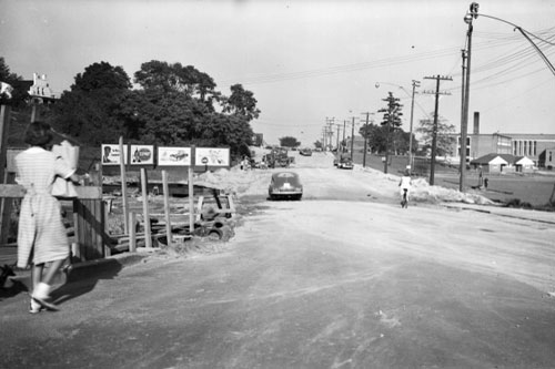
The Thomas G. Elgie House is the oldest surviving house in Leaside, built in the 1880’s by Robert Elgie, The house sat on a vantage point overlooking the picturesque Walmsley Brook. Since then, streets have been laid out, and lands have been subdivided, but the Elgie house remained as a testament to those earlier times. At least that is until 2013, when an application came to the committee of adjustment for consents to sever the property into three lots, and several “minor variances” to permit a major infill development. The City moved to designate the property in 2014; it was previously listed on the City’s Inventory of Heritage Properties in 2004.
A key issue that emerged was whether the placement of the house was to be specified as a heritage attribute in the designation. This is important because the developer wished to move the house forward on the lot. Heritage groups like the North York Community Preservation Panel took the position that the cultural heritage value of the property included both the original 19th century house, and the landscape features of the farmhouse in its original setting, such as the elliptical driveway, lawns, and mature trees (see photo). The Toronto Preservation Board recommended that the Heritage Attributes include “the specific location, setback and orientation of the building on the west side of Bessborough Drive, north of Parkhurst, where the east side elevation of the house faces the street and is viewed across a landscaped setting from Bessborough.”
The Committee of Adjustment rejected the severance of the property at 262 Bessborough into three lots, and the minor variances required for proposed development of the lots to be created. The OMB heard the case, and a settlement was reached which did involve the lot split and a move forward of the house, albeit a reduced amount. The house was designated under the Ontario Heritage Act, and has a heritage easement (but no plaque!)
Stop 3: Eglinton and Donlea/Bessborough Drives
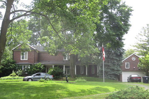
Leaside High School
Leaside High School is situated on the site of the original home built by Thomas Elgie, (the father of Robert Elgie (Elgie House), who purchased the 200 acre property, which stretched south and east from Bayview and Eglinton, in the 1860s.
The Leaside High School building was opened in September, 1948, three years after its official inauguration in September, 1945. Leaside High School celebrates its 75th anniversary in October, 2020.
1 Donlea Drive
1 Donlea Drive located at the east side of Donlea and Eglinton, is a curiosity, presenting as an English cottage, quite unlike the red brick Revival style typical of Leaside.
Built of plain brick in 1948 for Howard Burrell, who became Mayor of the Town of Leaside in the 1950s, this rambling house underwent a full makeover over 30 years ago by a Scottish owner who strove to make it a replica of a postcard cottage in England. The walls were stuccoed and whitewashed, leaded-glass windows were installed and, when city fire codes foiled plans to crown the house with several tons of hay thatch shipped from Britain, an imitation thatch roof was made with cedar shingles.
“That roof is unique to North America,” says former owner John Milne, a retired commercial designer and antiques enthusiast. “It was a Scotsman who did it and he later moved to a castle in Scotland and opened a bed and breakfast.”
“When the house was first built, the strip of Eglinton Avenue on which it sits was just a dirt road”, Mr. Milne says. Now, only a scallop-edged white-picket fence shields the property from whooshing buses and cars.
But indoors, where noise is excluded by double-glazed leaded windows and an attached coach house that fronts on Eglinton, a sense of timelessness prevails.
Around the home are 800 square feet of professionally landscaped garden with apple, pear and apricot trees, raspberry bushes, wild roses and a pond with a little stone bridge.
Source: Jane Gadd, Globe and Mail.
https://www.theglobeandmail.com/real-estate/postcard-cottage-is-a-gardeners-delight/article18175993/
Bessborough parkette and its missing plaque
The un-named parkette at the north-west corner of Bessborough and Eglinton overlooks the playing field at Leaside High School. In its centre sits a tree, girdled by an impressive wrought iron fence, which is the (former) site of a plaque, which mysteriously disappeared, sometime in 2014. Local resident, Geoff Clark, noticed it to be missing while on one of his daily walks in the area. It’s still missing, and he would like to see it put back. But the question is, what did it commemorate, and who placed it? In response to this intriguing question, Doug Bingley a former Leaside resident, wrote in to Leaside Life to say that he recalls his older sister telling him in the mid 1960’s that the fence was built around a tree planted by Queen Elizabeth ll when she visited Toronto in the 1950’s.
PS Actually this is not the first time a Leaside plaque has disappeared (See Stop 8 – Broadway and Brentcliffe – First Air Mail).
Stop 4: Bessborough Drive and Broadway Ave.
Bessborough Drive
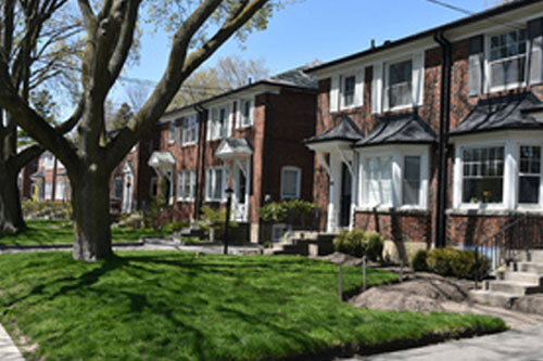
North Leaside was developed later (1950s), than central and south Leaside (1930’s and 40’s), and as noted with respect to Sunnybrook Plaza, reflects the wider adoption of a car culture in the later period, such as the prevalence of a single or occasionally double garage located beside the house. The larger lots and the greater interest in accommodating the car gives North Leaside more of a “suburban” vibe. However the red brick Revival styles typical of central Leaside are generally maintained, and there is still a diversity of housing types, with several streets having stretches of semi-detached houses – like Divadale Drive (east), Thursfield Crescent, and Eglinton east of Laird. And walk up apartments are found along Eglinton at, and east of Brentcliffe Road.
In the 1930’s, 40’s and 50’s houses were generally built by builders, family owned businesses who purchased lots and built houses based on purchased plans (not architect designed).
In the case of 297 to 309 Bessborough Dr. north of Divadale, the builder was Horace and Phyllis Brockington. According to their daughter, Linda Brockington McCarthy, who was raised in Leaside, they usually built three homes a year, and sold them for approximately $5,000 each, using that money to build three more.
In 1948 Linda’s parents purchased the lots along the north side of Donlea from Eglinton to Hanna Rd. That year they completed 4 Donlea, which became their long term family home, and where her parents lived for the rest of their lives. Like 73 Fleming, 4 Donlea also had some Art Moderne influences (low slung and with curving windows), but the house has been substantially changed by recent renovations.
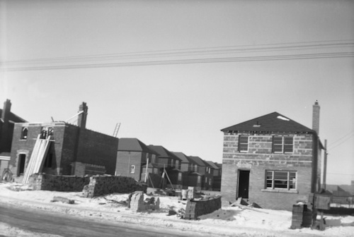
The house construction scene on Broadway is shown in the archival photo from 1949.
In North Leaside, the built form character, like that of Leaside generally, typically reflects that dwellings and landscape occupying the site do not “stand out”; indeed the dwellings (massing, height, architectural style and materiality) fit with other dwellings on the street.
Stop 5: Northlea Public School
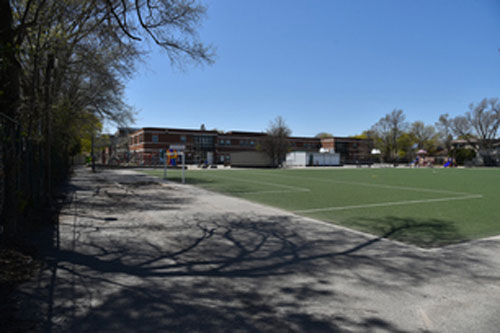
Northlea Elementary and Middle School on Rumsey Road is located on the site of the old Divadale Estate. It was opened in 1944 and at the time had 5 classrooms, with 6 more classrooms built in 1945. The architect was B.R. Coon, who previously (1922) had designed Leaside Public School (later renamed as Bessborough Public School).
North Leaside was developed without having an area designated for a park. The schoolyard of Northlea School has long served as the community park.
Stop 6 and 7: Broadway and Brentcliffe
The Twin Island Parkettes
Leaside’s lot fabric is an historical artifact that remains key to its unique physical character. In north Leaside the lot fabric consists of a modified grid pattern in the south, and relaxed curves in the north and east, which respect the adjacent ravine. The place where these two patterns intersect is at Broadway (the grid) and Brentcliffe (the curve) to create twin (west and east) triangular islands, which are parkettes.
The North Leaside lot fabric creates some unusual individual lots like the bulbous shaped lot at 79 Brentcliffe. This was the site of an application for consent to sever the lot into two, which was refused by the Toronto Local Appeal Board (TLAB) in January 2020 upon the refusal of the committee of adjustment application. The Broadway/Brentcliffe/Broadway intersection is characterized by a restrained intermingling of dwellings and landscape. As such, the reduced dimensions of the proposed lots, the increased massing and lot coverage, and the loss of mature trees would represent a significant change in the character of the neighbourhood.
Stop 6: Northlea United Church
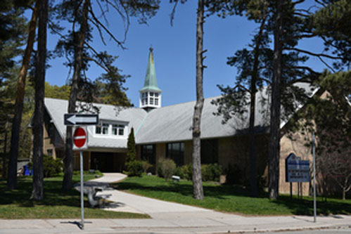
Northlea United Church occupies the south facing lot across from the “west island” parkette at Broadway/Brentcliffe and Don Avon. The Church was built in 1954 and designed by Barnett and Rieder, architects. The fine stand of pine trees on the west side makes a great location for seasonal “Carolling in the Pines”.
Stop 7: Canada’s First Airmail Plaque
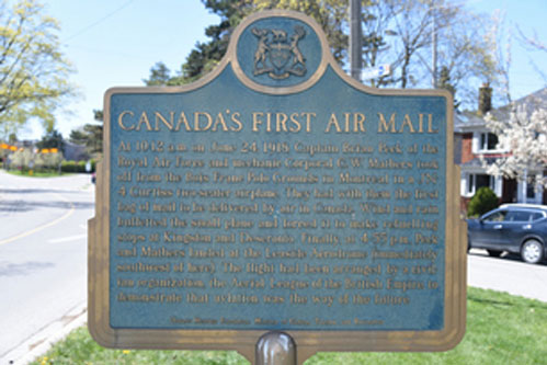
Canada’s First Airmail heritage plaque sits on an island where Broadway and Brentcliffe converge. Jane Pitfield in her book “Leaside” describes how the plaque commemorating the 40th anniversary of Canada’s first airmail flight in 1918 was placed in front of the apartment building at 970 Eglinton East, marking the site (Leaside Airport) where the plane touched down. However it later disappeared, and was replaced, but not in the same place. The Brentcliffe/Broadway Parkette was thought to be a “less vulnerable location” than Eglinton Avenue.
Stop 8: Broadway and Rykert
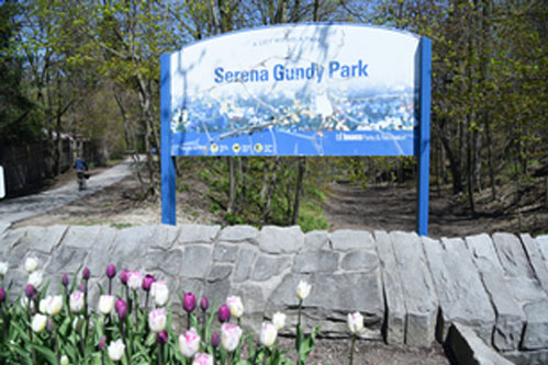
Serena Gundy Park Entrance
Serena Gundy Park – named after the first wife of the late James H. Gundy, head of the Wood Gundy securities firm – is located in the valley of the West Don River downstream (east) of where Burke Brook joins the West Don River. The north Leaside entrance to Serena Gundy Park (across from the intersection of Rykert Crescent with Broadway Avenue has a commemorative plaque on the wall to the right on which is written:
“This was Serena Gundy’s garden. She loved it and would be happy to share it with others”.
The Gundy family owned the lands, and the plaque, dated March 8, 1960, marks their transfer to Metropolitan Toronto. Indeed the terms of the land transfer require that the park be used “…for the purposes of a Public Park for the free use, benefit and enjoyment of the citizens of the Municipality of Metropolitan Toronto, such park to be known as ‘Serena Gundy Park’ “.
Hopefully Serena Gundy is happy with the current condition of the entrance. That might not have been the case back in 2014 when the grey stone wall was cut back to allow heavy equipment through the entrance! (For the story, see Leaside Life News, #41, September 2015 and #44, December 2015).
Regardless, generations of North Leaside kids have had amazing adventures there. According to Linda Brockington McCarthy it was “the entrance to a wild world of forest, ravine and tadpoles (Don River)”.
Curvaceous Rykert Crescent has large ravine lots on the north/east side and (just) large lots on the south/west side.
Rykert Crescent intersects with Thursfield Crescent which is comprised of a double row of semi-detached houses through to its terminus at Laird Drive.
Stop 9: Laird and Eglinton
Laird in Focus re-development
The Eglinton LRT and the station at Laird are driving massive change in the area, so far limited to the south side from Laird to Brentcliffe with mixed use tower projects approved for 915-845 Laird (RioCan) and 939 Eglinton (Diamond).
Laird to Sutherland – Eglinton
This stretch of Eglinton presents as typical main street commercial, at least on the north side, with two storey retail and office or residential above. The buildings include the Trinity Grace Church (former Leaside Bible Chapel).
Suomi-Koti – 795 Eglinton Avenue East
Suomi-Koti, the Finnish-Canadian Seniors Centre is a residential and nursing home facility on the south side of Eglinton that has 88 self-contained apartments available to seniors on a life-lease or on a rental basis. The architect was Seppo Kanerva who also designed two other seniors’ buildings in Leaside (Leaside Gate and Stay At Home In Leaside). Suomi Koti was completed in 1982.
Graffiti Art
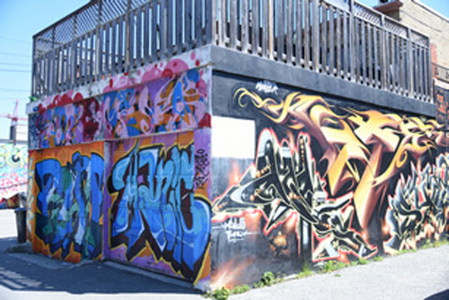
Laird to Sutherland – Leaside’s Graffiti Alley
The un-named laneway from Laird to Sutherland behind the Eglinton facing main street is Leaside’s “Graffiti Alley”. Pancheta (Pat) Barnett, President of the East York Historical Society has been advocating for the lane to be named “Barbers’ Lane” in honour of all the barbers who served in Leaside, and especially the ones who were burnt out of their business in a 1989 fire nearby on Eglinton. This follows an unsuccessful effort to name it John Lea Senior Lane after the founding Lea family member.